SmartData Solutions® is COLUMBIA Technologies’ cloud-based decision-support system that integrates high-resolution data collection and interactive reporting tools to optimize the evaluation and design of soil and groundwater remediation programs. SmartData Solutions® provides customers access to proven, real-time investigation, analysis and visualization techniques that map subsurface contamination, track soil and groundwater changes and profile existing remediation systems.
COLUMBIA Technologies are Environmental Scientists who provide high-value information assets that enable site managers to reduce the risk, uncertainty and costs of contaminated site cleanup and remediation. Through skilled application of science and technology, data best practices, engineering expertise and collaborative teamwork, we reduce your life-cycle cost of environmental liabilities by 40% or more enabling you to create a more financially and environmentally sustainable future.
SmartData Solutions® REAL-TIME DATA. REAL-TIME RESULTS
SmartData Solutions® is COLUMBIA Technologies’ cloud-based decision-support system that integrates high-resolution data collection and interactive reporting tools to optimize the evaluation and design of soil and groundwater remediation programs. SmartData Solutions® provides customers access to proven, real-time investigation, analysis and visualization techniques that map subsurface contamination, track soil and groundwater changes and profile existing remediation systems.
Compared to the low capture rates of previous data collection approaches, SmartData Solutions® delivers the volume, quality and insight to yield sustainable outcomes:
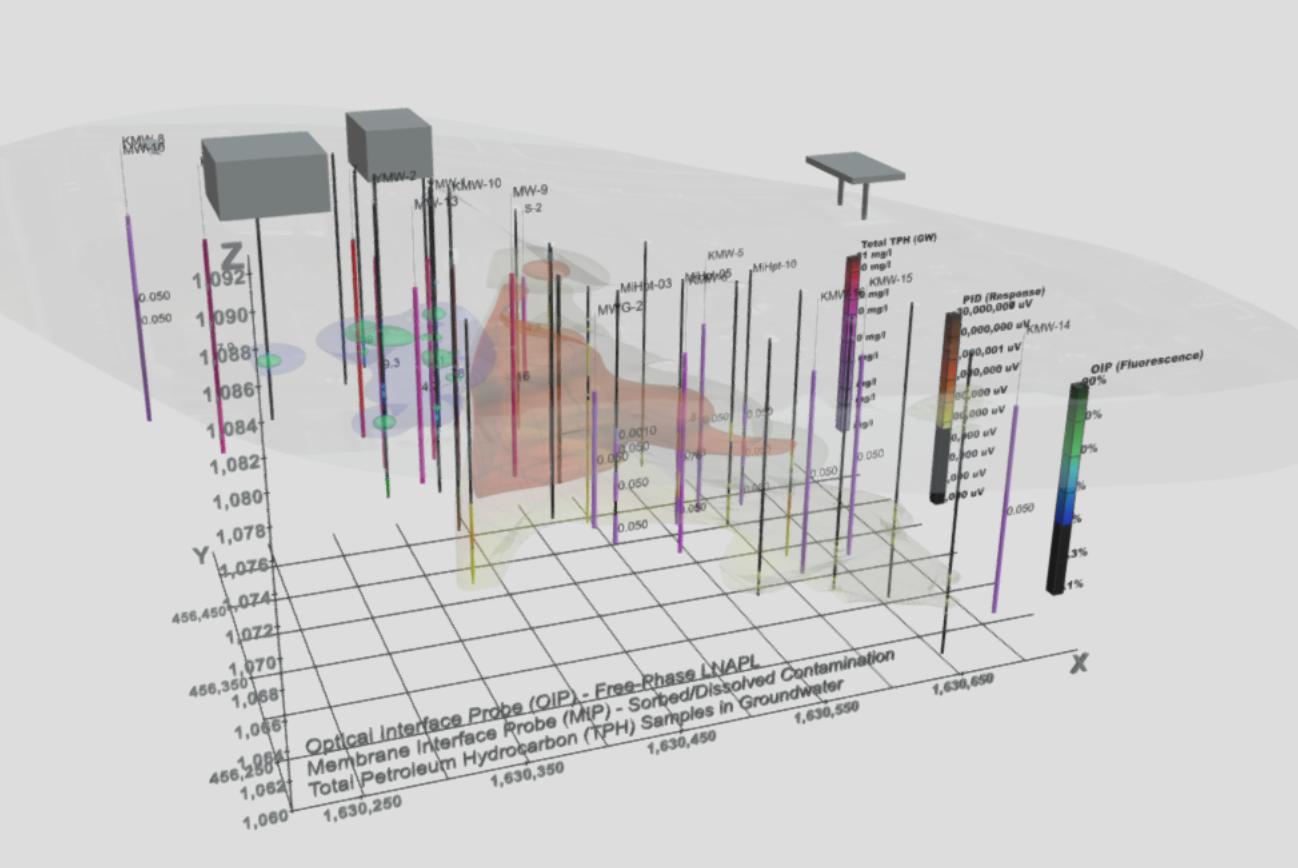
- Best Data. High-resolution data of the lateral and vertical extent of soil and groundwater contamination.
- Deepest Understanding. A complete overview of local site geology, hydrogeology, geochemistry, and contaminant chemistry.
- Pinpoint Recommendations. More accurate delineation for the best possible remediation design.
Using a browser, managers can view GIS-based data as it is generated, ask questions while performing their own investigation and analysis and reduce the time for budgeting and technical decision making. Given that SmartData Solutions® provides all of these capabilities available through the cloud, it improves collaboration among project managers, decision-makers and other stakeholders, wherever they are.
SmartData Solutions® Features at Glance
- Password-protected secure website to review project data
- Real-time updates of direct sensing data after every borehole
- Immediate and complete QA/QC check on field data with each update
- 24×7 access to all data logs and raw data files
- Email notification as new data becomes available
3D Model Options with SmartData Solutions®
SmartData Solutions® direct outputs are compatible with multiple 3D modeling software options. Evaluate your data in real-time, perform critical quality control checks, and directly output your SmartData files for 3D rendering and hosting. Click here for an example 3D model created in EVS with data output from SmartData Solutions®.