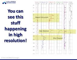
Would a comprehensive site assessment and better data with multiple technology integration make a difference in your overall scope? Before you answer that question, think about whether or not having better, more accurate, and real-time information would motivate you to change your investigation technique on your next project. Are you actually interested in having data that accurately depicts the plume, delineates your source area, and multiple lines of evidence on your subsurface contamination? Or, would you rather “drill blind” and continue to sample areas where you think there may be contamination and install monitoring wells at the wrong depth and location incurring additional costs and time?
If having better data would actually change the way you would execute your project, design a remediation plan, or install monitoring wells, please read on. If you disagree, you may also continue to read, but the thoughts below may conflict with your perspective. Just saying, we warned you.
Data which is collected with advanced direct sensing tools (such as the Membrane Interface Probe (MIP), Laser Induced Fluorescence (LIF), or Hydraulic Profiling Tool (HPT)) provide a greater level of detail for characterizing the local site geology, a more in depth understanding of the hydrology, and deeper insight into the contaminant chemistry of your site. Wouldn’t all of this allow you to make more informed decisions?
Sure, we’re asking a lot of questions, but wouldn’t it be of value if this information was processed in real-time enabling yourself and decision makers to design a more effective remediation plan? Application of direct sensing tools allows one to quickly locate and characterize chemical contaminants, not only in the plume, but throughout the source area.
Why settle for the assessment report weeks later when the information you need to make better decisions is available now? Our SmartData Solutions® platform delivers results at greatly reduced costs versus traditional monitoring soil and groundwater sampling methods, providing detailed soil lithography and chemical levels in days, not weeks. Our detailed process with 3D imagery of the location, depth, and composition of the contaminant is ideal for:
- Project Planning
- Rapid Site Assessments
- Risk Avoidance
- Targeted Cleanup
- Monitoring Cleanup Effectiveness
Throughout the hundreds of sites that we’ve successfully characterized, our experienced engineers and scientists have learned that knowledge is power and better data delivery enables project managers to make better informed decisions. Many projects engage in a lot of sampling, yet the involved parties are still puzzled as to the source and the extent of the contamination. Literally, years and money are wasted following the “data-lean” approach to assessing a site – using monitoring wells and a few samples to the lab. We’re not saying don’t install monitoring well or conduct sampling efforts, rather make sure that you find the target using high resolution site assessment data.
Below are three areas where the concept of knowledge is power is demonstrated:
- The ability to see data in the ground as pushes are taking place to gain a better sense of what is underground and the ability to develop a dynamic work plan driven off of the site data which is being collected. In addition, we also help you validate your conceptual site model before you leave the field.
- Real-time live delivery of the results to the entire project team, so that the best decisions are made while the team is still in the field.
- The capability to draw on hundreds of projects and help you turn the raw data into knowledge. Our SmartData Solutions® processing package produces easy to understand and reliable 3D visual images of the geology and the contaminants.
Too often, wells are placed in the wrong locations or remediation treatment of a zone which is too shallow/deep occurs because an ineffective site characterization took place. Site investigations frequently leave us with unanswered questions regarding where the contamination really is. Using a sophisticated array of direct sensing tools coupled with SmartData Solutions® enables the team to quickly locate contamination plumes. Our experience shows that the right tools will help you locate and collect meaningful samples, the right sampling strategy will help you focus on remediation, and the right contractor will help you shorten the investigation and remediation cycle. Using a vertical profiling approach, with high resolution technologies, allows you to locate where the contaminant lies and gives detailed information on subsurface stratigraphy. Once the location is know, confirmation soil and groundwater samples can verify the information provided by the vertical profiles.
After reading through why comprehensive site assessments and better data make a difference, do you feel a level of urgency to conduct your next project using direct sensing tools? Or, would you rather “drill blind” and continue to sample areas where you think there may be contamination and install unnecessary monitoring wells incurring additional costs and time?


